Thursday, April 30, 2015

Types of Wall Rock Alteration


Types of Wall Rock Alteration

Types of Wall Rock Alteration
1. Potassic alteration
ØPotassic (or K-silicate) alteration is characterized by the formation of new K-feldspar and/or biotite, usually together with minor sericite, chlorite, and quartz.
ØAccessory amounts of magnetite/hematite and anhydrite may occur associated with the potassic alteration assemblage.
ØIt typically represents the highest temperature form of alteration (500–600°C) associated with porphyry Cu-type deposits, forming in the core of the system and usually within the granite intrusion itself.
ØPyrite and minor chalcopyrite and molybdenite are the only ore minerals associated with this alteration.
ØNot all K-feldspar alteration is characterized by the presence of reddish colouration.

2. Phyllic (or sericitic) alteration
ØThis alteration style is the most common in a variety of hydrothermal ore deposits and forms over a wide temperature range by hydrolysis of feldspars to form sericite (fine-grained white mica), with minor associated quartz, chlorite, and pyrite.

ØPhyllic alteration is associated with porphyry Cu deposits, but also with mesothermal precious metal ores and volcanogenic massive sulfide deposits in felsic rocks.

Types of Wall Rock Alteration

3.  Propylitic alteration
ØPropylitic alteration is probably the most widespread form of alteration.
ØIntermediate argillic alteration affects mainly plagioclase feldspars and is characterized by the formation of clay minerals kaolinite and the smectite group (mainly montmorillonite). It typically forms below about 250°C by H+ metasomatism and occurs on the fringes of porphyry systems.
ØAdvanced argillic alteration is characterized by kaolinite, pyrophyllite, or dickite (depending on the temperature) and alunite together with lesser quartz, topaz, and tourmaline. This type of alteration is characteristic of many epithermal precious metal deposits and a smaller number of mesothermal deposits such as Butte, Montana.

4. Silication

ØSilication is the conversion of a carbonate mineral or rock into a silicate mineral or rock. It is the main process which accompanies the prograde stage in the formation of polymetallic skarn deposits which develop when a fertile, acidic, magmatic fluid infiltrates a carbonate host rock.

 5. Silicification
ØSilicification should not be confused with silication and refers specifically to the formation of new quartz or amorphous silica minerals in a rock during alteration.


Types of Wall Rock Alteration.

6. Carbonatization (Dolomitization)
ØIs the formation of carbonate minerals (calcite, dolomite, magnesite, siderite,etc.) during alteration of a rock. As dolomite in association with amphibolite, siderite in a banded iron-formation, or calcite in a granitic host.

7. Greisenization
ØA process of hydrothermal alteration in which feldspar and muscovite are converted to an aggregate of quartz, topaz, tourmaline, and lepidolite (i.e., greisen) by the action of water vapor containing fluorine. Ref

8. Tourmalinization
ØMedium to high temperature alteration. Associated with many tin and gold depositsQuartz-sericite-tourmaline veins and alteration common.

Types of Wall Rock Alteration

9. Hematitization
ØAlteration that is associated with oxidizing fluids often results in the formation of minerals with a high Fe3+/Fe2+ ratio and, in particular, hematite with associated K-feldspar, sericite, chlorite, and epidote.

10. Fenitization
ØA fenite is a quartzofeldspathic rock that has been altered by alkali metasomatism at the contact of a carbonatite intrusive complex. The process is called fenitization. Fenite is comprised mostly of alkalic feldspar, with some aegirine, subordinate alkali-hornblende, and accessory sphene and apatite. Chemically, fenites are Na- and K-rich silicate rocks which develop at the contact between alkaline (carbonatite) igneous intrusions and their surrounding country rocks.

11. Chloritization
ØChlorite may result from alteration of mafic minerals or introduction of Fe and/or Mg. Very common surrounding plumbing of sea-floor massive sulfides.


12. Bleaching
ØNot characterized by any specific mineral assemblage, but rather a color change between altered and unaltered rock. Generally the result of oxidation of Fe.

Comments By


Alteration is a complex process of ion exchange whereby some constituents are removed, others are added and still others are merely redistributed. The physical effects of alteration include recrystallization, changes in permeability and changes in colour.

Carbonate rocks are characteristically recrystallized along the borders of a vein or near an igneous contact. Conversely argillization may reduce permeability of a rock, leaving the orebody enclosed within a relatively impermeable shell.

Colour changes include bleaching, darkening and production of aureoles (zones) of various colours. Pastel colours are especially prominent around certain ore deposits and may form conspicuous leads to the ore.

Pyrite is a standard alteration product around sulphide ore deposits (since iron is one of the most abundant metals in the earth's crust). Pyrite forms whenever sulfur is added to a host rock containing iron or ferro-magnesian minerals. Pyrite causes a striking colour change e.g. the pyritization of a red sandstone or shale will produce a bleached zone due to reduction of iron. Conversely, any pyritized rock is likely to be made conspicuous at the surface by oxidation of iron which will produce a red, brown-red or yellow weathered zone.
Unstable (not in equilibrium) rocks undergo physical and chemical changes (in order to attain equilibrium) in the presence of early ground preparing hydrothermal fluids of ore solutions.
The alteration may be very subtle (hydration of ferromagnesian minerals) to very intense (silicification of limestones). 
Indeed replacement ores are merely commercially valuable products of wallrock alteration. 
Wallrock alteration has been recognized a valuable tool in exploration, because the alteration haloes around many deposits, are widespread and easier to locate than the orebodies themselves. 
At various distances from a vein, the conditions of temperature and chemistry are usually different. As a result of this different types of alteration are likely to be produced simultaneously at various distances from the vein or fissure. For example, in the outer fringes of the alteration zone, the ferromagnesians may have been slightly hydrated while the interior zone was being silicified or sericitized, and the intermediate zone argillized. The product of this is a zoning of different alteration products arranged symmetrically around the central vein. In some deposits this zoning is conspicuous and may be an excellent guide to ore.
TYPES OF WALL-ROCK ALTERATION
Now coming to the exact question raised, the types are varied and manifold. About 10 types are being named as under though numerous permutations and combinations often tend to produce mixed variables. To name the types : Argillic(kaolin+montmorillonite+dickite+pyrophyllite), Potassic(potash feldspar+biotite), Phyllic(quartz+sericite+pyrite), Propylitic(chlorite+epidote+calcite), Silicification (quartz+chert), Dolomitization, Feldspathization, Greissenisation, Fenitizaztion and Bleaching.

Ref: Wallrock Alteration - S. Farooq, Dept of Geology Aligarh Muslim University, India

www.geol-amu.org/notes/m7-1-8.htm: Extracted from Google page (Internet Search).
Share:

The Herradura Gold Mine

La Herradura Gold Mine

La Herradura Gold Mine .

Location: Sonora, Puerto Penasco, Mexico (MX).
Products: Gold.
Owner: Fresnillo plc.
Average ore grade in reserves: 0.80 g/t Gold
Total Reserves: 1.5 Moz Gold
Mine Life: 4.1 years

MINING AND EXPLORATION HISTORY

The La Herradura mine contains 5.4 million ounces of contained gold in production plus reserves. The deposit is owned by Minera Penmont, a Joint Venture between Peñoles and Newmont. As a result of an aggressive grassroot exploration program in northwestern Mexico that started in 1987, the first economic drill intersection in La Herradura came in 1991 (100m @ 0.85 g/t Au). Subsequent and continuous drilling campaigns resulted in the definition of an orebody containing 1.7 M oz by May 1998, when mine operations started. To date, 2 M oz of gold have been produced. Present reserves are 3.4 M oz of gold in ore with an average grade of 1 g/t, using a cut-off of 0.35 g/t Au. The mine produces 210,000 ounces of gold per year ( Jose de la Torre, pers. commun., 2008).

Regional Geologic and Tectonic Setting

La Herradura mine is located in northwestern Sonora, Mexico. This deposit occurs within a northwest trending belt that consists of metamorphic rocks of greenschist and amphibolite facies and granitoids of Proterozoic age (Nourse et al., 2005). These rocks are intruded by a series of Triassic and Middle Jurassic granitoids and are overlain by younger sedimentary and volcanic rocks of Middle to Late Jurassic age (Figure 2.1). All these units are intruded by Late Cretaceous to early Tertiary granitoids related to the Laramide orogeny and are overlain by Miocene rhyolites, andesites, and basalts and Quaternary basalts. Basin and Range tectonics affect this area, as they do much of Sonora and adjacent Arizona. Basin and Range faulting occurred in the mid to late Tertiary. Faulting resulted in the formation of NW-trending linear ranges of crystalline rock, separated by deep basins filled with sand and gravel derived from the ranges. Correlation is difficult between ranges.

The Geologic Setting of La Herradura
La Herradura mine occurs within a northwest trending belt of Proterozoic rocks consisting of greenschist and amphibolite grade metamorphic rocks and granitoids. The deposit is hosted in biotite-quartz-feldspar and quartz-feldspathic gneisses that are bordered to the east by Jurassic clastic rocks and subvolcanic intrusions and to the west by upper Paleozoic limestone. Isolated outcrops of fresh andesite, trachyte, and basalt occur locally northeast of the mine.

The Structural Setting of La Herradura
Based on structural mapping in the La Herradura mine area, it is possible to identify at least five tectonics events superimposed on all stratigraphic units outcropping in this area (de la Torre, 2004; Romero 2005, Table 2.1). These observations indicate that gold mineralization is associated with the third tectonic event, and they also tend to constrain the age of this mineralization to between 80 and 45 Ma.

Alteration of La Herradura
Reported alterations assemblages of this deposit (de la Torre, 2004; Romero, 2005) are quartz-sericite-albite in the core of the deposit and selectively follow the quartz-feldspar gneiss bands in the outer zones of the deposit. Iron-carbonates (ankerite-siderite) are widespread within the deposit, mainly restricted to haloes adjacent to quartz-sulfide veins within the core of the orebody. Iron carbonates also are found in the outer alteration aureoles of the deposits. Propylitic alteration islocated in the outermost portions of the deposit, and it occurs mainly in the biotite-bearing gneiss and in Jurassic rhyolitic and andesitic volcanic rocks.
Share:

Batu Hijau Copper, Gold Mine

Batu Hijau Gold Mine

Batu Hijau Gold Mine

Location: Sumbawa, West Nusa Tenggara, Indonesia.
Products: Copper & Gold.
Owner: P.T. Newmont Nusa Tenggara.
Ore Type: Porphory Copper deposits.
Reserves: the Batu Hijau included 2.77 million tonnes of copper with an average grade of 0.69g/t gold, which would allow mining to continue until 2025.

Ore geology and Mineralization: The Batu Hijau porphyry Cu‐Au deposit is a world‐class island arc type porphyry deposit, located on the southwestern portion of Sumbawa Island, Nusa Tenggara Barat Province, Indonesia. This 12 km by 6 km district contains an estimated 914 million tonnes of ore at an average grade of 0.53% Cu and 0.40 g/t Au (Garwin, 2002; Arif and Baker, 2004), and is one of the largest and richest porphyry Cu‐Au deposits in Asia.
Ore fluids produced distinct quartz ± sulfide veins and veinlets that cross cut the tonalite intrusions and their surrounding host rocks. Within these veins, fluid inclusions trapped in quartz contain ore fluids, which represent fluids moving through the deposit during the time of its formation. The ore fluids in the fluid inclusions are key to defining the temperature and pressure conditions under which the deposit formed, and defining the geochemistry of the hydrothermal system, which was responsible for the distribution Cu and Au within the deposit.
Preliminary fluid inclusion studies have suggested that deposit formation temperatures ranged from 280 to over 700 °C. Based on the coexistence of magnetite‐bornite ,chalcocite, Garwin (2000) suggested that the earliest veins at Batu Hijau likely formed at > 500–700 °C (cf. Simon et al., 2000). A preliminary fluid inclusion study by Garwin (2000) on inclusions in halite‐bearing transitional veins produced homogenization temperatures that ranged from about 450 to 500 °C. These temperatures are consistent with phase equilibria temperature estimates based on a chalcopyrite , bornite vein mineralogy (Simon et al., 2000).
Homogenization temperatures of < 400 °C were obtained by Garwin (2000) for late pyrite‐bearing veins. A fluid inclusion study conducted by Imai and Ohno (2005) documented homogenization temperatures ranging from 280 to 454 °C, significantly lower than temperatures obtained by Garwin (2000). This temperature is similar to Au saturation temperatures for bornite (~300 °C) and chalcopyrite (250 °C) (Kesler et al., 2002; Arif & Baker, 2004).
A detailed fluid inclusion microthermometry study to clarify processes of ore formation is warranted. Microthermometric data on well‐characterized fluid inclusions with appropriate pressure corrections can provide the temperatures and pressures at which the deposit formed. Additional qualitative and quantitative data from synchrotron x‐ray fluorescence (SXRF) and laser ablation inductively coupled plasma mass spectrometry (LA‐ICP‐MS), respectively, can document and quantify major and trace element concentrations. Such data will contribute to a model describing the transport of metals by hydrothermal fluids, and the precipitation of Cu‐ and Au‐bearing minerals.

Mining & Milling: Batu Hijau is an open-pit mine. Ore is removed from the mining face using P&H 4100 electric shovels (pictured) and loaded into Caterpillar 793C haul trucks. Each haul truck can move a payload 220 t (240 short tons) of ore. The trucks haul ore from the shovel to primary crushers. Crushed ore is sent by a conveyor 1.8 m (6 ft) wide and 6.8 km (4.2 mi) long to the mill. Daily production from the mine is an average of 600,000 t (660,000 short tons) ore and waste combined. Ore from the mine has an average copper grade of 0.49% and an average gold grade of 0.39g/t.

Crushed ore is further reduced in size by Semi-Autogenous Grinding and ball mills. Once milled it is sent through a flotation circuit which produces a concentrate with a grade of 32% copper and 19.9g/t gold. The mill realizes a copper recovery of 89%.[3] The concentrate is thickened into slurry and piped 17.6 km (10.9 mi) to the port at Benete where water is removed from the slurry. The concentrate storage at the port can hold 80,000 t (88,000 short tons) of copper-gold concentrate.
Share:

Wednesday, April 29, 2015

Boddington Gold Mine

Boddington Gold Mine

Boddington Gold Mine


Location: Boddington ,Western Australia. 
Ore Type: Lode Deposits.
Products: Gold. Secondary Copper.
Owner: Newmont Mining.
Reserves: By the end of 2011, proven ore reserves at Boddington were 20.3 million ounce (moz) of gold and 2.26 billion pounds (blbs) of copper.

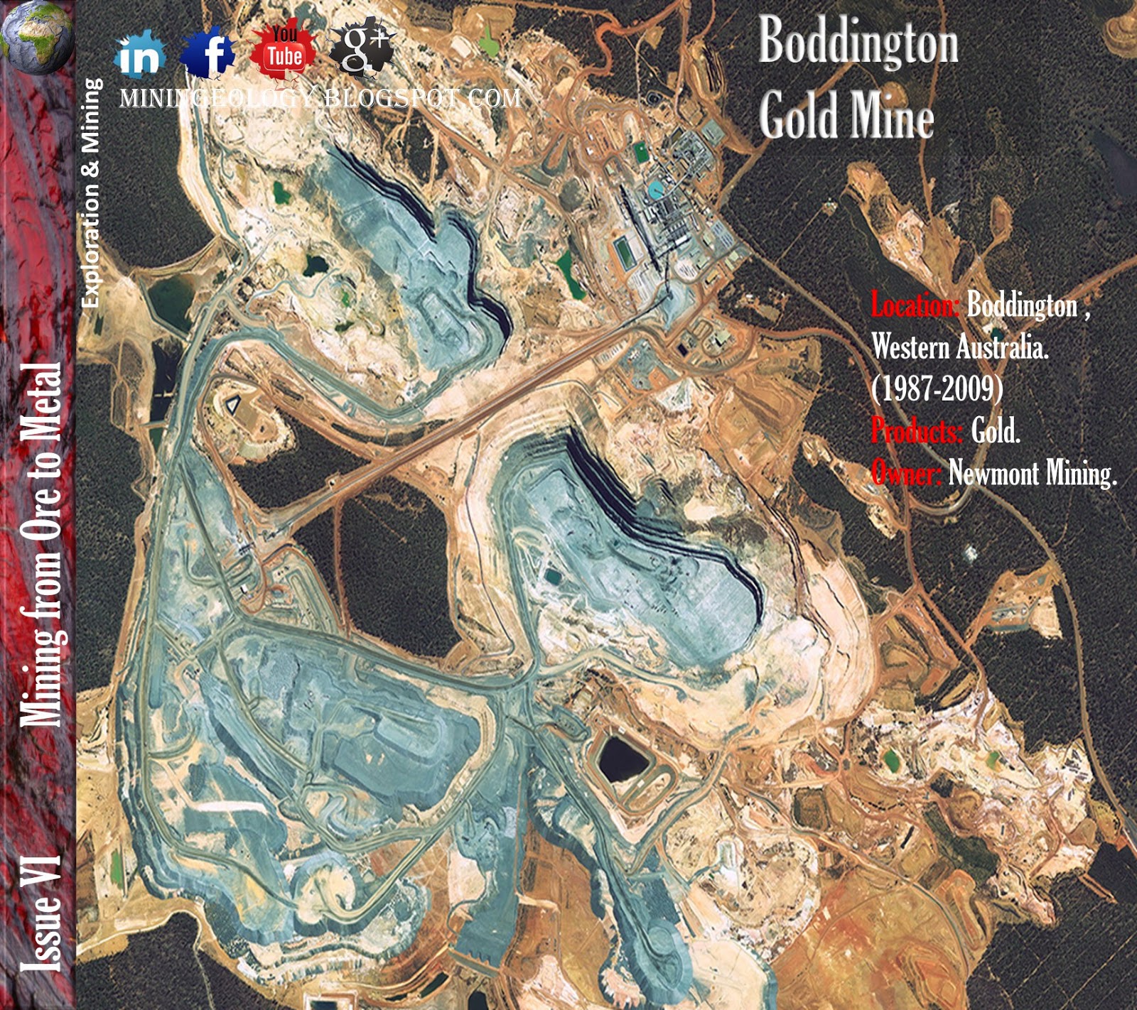
Overview: Boddington Gold Mine (BGM) is located about 130km south-east of Perth in Western Australia. The largest gold mine in the country, it is poised to become the highest producing mine once production ramps up over the next few years. The $2.4bn project was initially a three-way joint venture between Newmont Mining, AngloGold Ashanti and Newcrest Mining. In 2006 Newmont bought Newcrest's 22.22% share, bringing its interest to 66.67% and ending any Australian ownership. AngloGold owned the remaining 33.33%. In June 2009, Newmont became the sole owner of the mine by acquiring the 33.3% interest of AngloGold. The original, mainly oxide open-pit mine was closed at the end of 2001.
The project has an attributable capital budget of between A$0.8bn and A$0.9bn. On 23 July 2009, the project, including the construction of the treatment plant, was completed. Production began in the third quarter of 2009. The first gold and copper concentrate was produced in August 2009.
Approximately 100,000t of ore was processed by mid-August. Gold production began on 30 September 2009. By 19 November 2009, the mine achieved commercial production. The mine was officially inaugurated in February 2010. The project had an attributable capital budget of between A$0.8bn and A$0.9bn. It employs 900 workers.
Based on the current plan, mine life is estimated to be more than 20 years, with attributable life-of-mine gold production expected to be greater than 5.7Moz.
In May 2012, Newmont decided to seek the expansion of mine life to 2052 by combining the north and south Wandoo open pits. It also plans to expand the waste rock facility to two billion metric tons.
Newmont and Anglo had focused their exploration activities on the poorly explored areas of the greenstone belt outside the already identified Boddington Expansion resource. The exploration strategy was to identify the resource potential of the remainder of the greenstone belt, with the emphasis on high-grade lode-type deposits.

Geological settings & Mineralization:
The Boddington gold mine is hosted in Archean volcanic, volcaniclastic, and shallow-level intrusive rocks that form the northern part of the Saddleback greenstone belt, a fault-bounded sliver of greenstones located in the southwestern corner of the Yilgarn craton, Western Australia. Total Au content of the Boddington gold mine (past production plus in situ resource) exceeds 400 metric tons, making the Boddington gold mine one of the largest Au mines currently operating in Australia.Geologic mapping and radiometric dating indicate that five phases of igneous activity occurred during development of the Saddleback greenstone belt. Basaltic, intermediate, and minor felsic volcanism occurred between approximately 2714 and 2696 Ma and again at approximately 2675 Ma. An older suite of ultramafic dikes was emplaced between approximately 2696 and 2675 Ma and a younger suite was emplaced between approximately 2675 and 2611 Ma. Granitoid plutons crystallized at approximately 2611 Ma and cut all the other Archean rocks in the Saddleback greenstone belt.Regional upper greenschist facies metamorphism accompanied the earliest phase of ductile deformation (D 1 ). Sericite-quartz + or - arsenopyrite-altered shear zones developed during subsequent ductile deformation (D 2 ). Crosscutting relationships indicate that D 1 and D 2 predate approximately 2675 Ma. Further ductile shear zones characterized by quartz-albite-sericite + or - pyrite alteration developed during D 3 , after approximately 2675 Ma. Narrow brittle faults (D 4 ) with biotite + or - clinozoisite alteration halos, active between approximately 2675 and 2611 Ma, cut the three generations of ductile shear zones.Rare quartz-albite-fluorite-molybdenite + or - chalcopyrite + or - pyrrhotite veins developed prior to D 1 and the regional metamorphism. These veins are not associated with any Au mineralization or significant Cu. Quartz + or - pyrite + or - molybdenite + or - Au veins and crosscutting clinozoisite-biotite + or - actinolite + or - quartz-chalcopyrite-pyrrhotite + or - galena + or - molybdenite + or - scheelite Au veins developed during movement on the D 4 faults between approximately 2675 and 2611 Ma. Mineralized veins crosscut the three generations of ductile shear zones but are not foliated. Movement on the D 4 faults controlled the location of mineralization within the Boddington gold mine. Higher grade mineralization occurs along the D 4 faults and coplanar pyroxenite dikes and where the faults intersect older shear zones, and quartz veins. Widespread lower grade stockwork mineralization is concentrated in the general vicinity of the D 4 faults. The orientation of veins within stockworks is consistent with vein development during sinistral strike-slip movement on the D 4 faults. Au-Cu + or - Mo + or - W mineralization at the Boddington gold mine, therefore, occurred late in the tectonic evolution of the Saddleback greenstone belt.The timing of mineralization at the Boddington gold mine is analogous to many other structurally late Au deposits in the Yilgarn craton, e.g., Mount Magnet, Mount Charlotte, and Wiluna. Movement on the D 4 faults and mineralization may have been coeval with the emplacement of granitoid intrusions at approximately 2611 Ma. Whereas these granitoids are unaltered and therefore unlikely to have been the source of significant volumes of hydrothermal fluids, they may have provided the thermal energy necessary to drive circulation of auriferous hydrothermal fluids through D 4 faults that may also have accommodated their intrusion.Previous workers at the Boddington gold mine have inferred that mineralization is genetically linked to subvolcanic intrusions emplaced between approximately 2714 and 2696 Ma. However, this inference is inconsistent with the crosscutting relationships of structures and mineralized veins which indicate that mineralization occurred between approximately 30 and 80 Ma after emplacement of these rocks.
General Geological Map of Boddington Gold Mine

Note From Dr. Walter L. Pohl

"Lateritic gold deposits as a class are a relatively recent discovery. One of the largest representatives of this group was the Boddington bauxite mine in Western Australia, which until closure in 2001 was the biggest gold mine in Australia with an annual gold production of 2500 kg. Premining resources amounted to 60 Mt of ore at 1.6 ppm Au, apart from bauxite with gold contents <1 ppm. Exploitable gold was located in near-surface, iron-alumina hard crusts that reached a thickness of 5 m and in additional 8 m thick lumpy Fe-Al laterite of the B-horizon. Sources of the gold in soil at Boddington are quartz veins and hydrothermally altered bodies of Archaean greenstone bedrock. Since 2009, resources of 400 Mt of this primary ore with a grade of 0.9 g/t Au and 0.12% Cu are exploited in a new mine. Worldwide, numerous lateritic gold deposits are worked. They are attractive because exploration, extraction and processing of soil is less costly compared with hard rock mining."

Share:

The Ranger Uranium Mine

The Ranger Uranium Mine


Location: Kakadu National Park, Northern Territory, Australia.
Products: Uranium.
Owner: Energy Resources of Australia Limited.
Deposit Type: Unconformity-related uranium deposits.

Overview: In 1969 the Ranger orebody was discovered by a Joint Venture of Peko Wallsend Operations Ltd (Peko) and The Electrolytic Zinc Company of Australia Limited (EZ). In 1974 an agreement set up a joint venture consisting of Peko, EZ and the Australian Atomic Energy Commission (AAEC).
In 1978, following a wide ranging public inquiry (the Ranger Uranium Environmental Inquiry) and publication of its two reports (the Fox reports), agreement to mine was reached between the Commonwealth Government and the Northern Land Council, acting on behalf of the traditional Aboriginal land owners. The terms of the joint venture were then finalised and Ranger Uranium Mines Pty Ltd was appointed as manager of the project.
In August 1979 the Commonwealth Government announced its intention to sell its interest in the Ranger project. As a result of this, Energy Resources of Australia Ltd (ERA) was set up with 25% equity holding by overseas customers. In establishing the company in 1980 the AAEC interest was bought out for $125 million (plus project costs) and Peko and EZ became the major shareholders. Several customers held 25% of the equity in non-tradable shares. Ranger Uranium Mines Pty Ltd became a subsidiary of ERA. During 1987-8 EZ's interest in ERA was taken over by North Broken Hill Holdings Ltd and that company merged with Peko. Consequently ERA became a 68% subsidiary of North Limited, and this holding was taken over by Rio Tinto Ltd in 2000. In 1998 Cameco took over Uranerz, eventually giving it 6.69% of ERA, and Cogema took over other customer shares, giving it (now Areva) 7.76%.
Late in 2005 there was a rearrangement of ERA shares which meant that Cameco, Cogema and a holding company (JAURD) representing Japanese utilities lost their special unlisted status and their shares became tradable. The three companies then sold their shares, raising the level of public shareholding to 31.61%.

Geological Features: 
Features associated with some of the unconformity-related uranium deposits in the Alligator Rivers, Rum Jungle and South Alligator Valley uranium fields are as follows (modified after Ewers & others, 1984; Mernagh, Wyborn & Jagodzinski, 1998): The host rocks occur in intracontinental or continental margin basins; the deposits are near to a late Palaeoproterozoic oxidised thick cover sequence (>1 km) of quartz-rich sandstone;
The basement is chemically reduced, containing carbonaceous/ferrous iron-rich units or feldspar-bearing rocks;
The deposits are associated with a Palaeoproterozoic/late Palaeoproterozoic unconformity and with dilatant brecciated fault structures, which cut both the cover and basement sequences and separate reduced lithologies from the oxidised cover sequence;
Most of the large deposits in the Alligator Rivers and the Rum Jungle fields are in stratabound ore zones and have a regional association with carbonate rock/pelitic rock contact, but an antipathetic relationship with carbonate in the ore zones;
The major Australian deposits lie close to an unconformity although the Jabiluka deposit is still open some 550 m below the unconformity;
The known major uranium deposits are present where the oxidised cover sequence is in direct contact with the reducing environments in the underlying pre-1870 Ma Archaean–Palaeoproterozoic basement and not separated by an intervening sequence, as by the El Sherana and Edith River Groups in the South Alligator Valley uranium field.
Geological map of The Ranger Uranium Mine.
Local stratigraphy of The Ranger Mine

Alteration
Alteration features associated with the deposits are:
Alteration extends over 1 km from the deposits,
Alteration is characterised by sericite–chlorite ± kaolinite ± hematite,
Mg metasomatism and the formation of late-stage Mg rich chlorite are common,
Strong desilicification occurs at the unconformity.
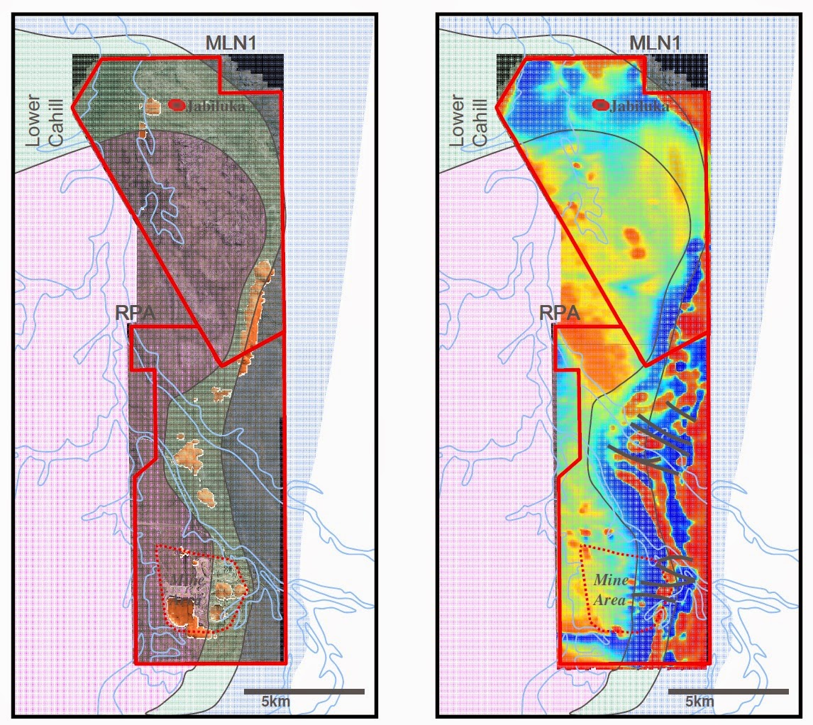
Alteration geophysics responses MLN1 RPA Lower
Alteration geophysics responses
Source of Uranium mineralization
Archaean and Palaeoproterozoic granites of the Alligator Rivers and South Alligator Valley uranium fields have uranium contents which are well above the crustal average of 2.8 ppm U (Wyborn, 1990a). Granites and granitic gneisses of the Nanambu complex contain 3–50 ppm U; tonalites, granitic gneisses and granitic migmatites of the Nimbuwah complex have 1–10 ppm U. The Nabarlek Granite that has been intersected in drill holes below the Nabarlek deposit has 3–30 ppm U, and the Tin Camp and Jim Jim Granites also have high uranium contents. The Malone Creek Granite (South Alligator Valley) has 11–28 ppm U. Wyborn (1990b) suggested that the underlying crust in the region of these uranium fields is enriched in uranium. Maas (1989) concluded from Nd–Sr isotopic studies that for Jabiluka, Nabarlek and Koongarra, the uranium was derived from two sources: the Palaeoproterozoic metasediments and a post-unconformity source, probably highly altered volcanics within the Kombolgie Subgroup. Maas (1989) also proposed that these orebodies formed when hot oxidising meteoric waters, which contained uranium derived from volcano-sedimentary units within the Kombolgie, reacted with reducing metasediments of the Palaeoproterozoic basement.
Uranium mineralization
Uranium mineralization 

Processing: Following crushing, the ore is ground and processed through a sulfuric acid leach to recover the uranium. The pregnant liquor is then separated from the barren tailings and in the solvent extraction plant the uranium is removed using kerosene with an amine as a solvent. The solvent is then stripped, using an ammonium sulphate solution and injected gaseous ammonia. Yellow ammonium diuranate is then precipitated from the loaded strip solution by raising the pH (increasing the alkalinity), and removed by centrifuge. In a furnace the diuranate is converted to uranium oxide product (U3O8).

Reserves & Resources: The Ranger 1 orebody, which was mined out in December 1995, started off with 17 million tonnes of ore some of which is still stockpiled. The Ranger 3 nearby is slightly larger, and open pit mining of it took place over 1997 to 2012.
In 1991 ERA bought from Pancontinental Mining Ltd the richer Jabiluka orebody (briefly known as North Ranger), 20 km to the north of the processing plant and with a lease adjoining the Ranger lease. ERA was proposing initially to produce 1000 t/yr from Jabiluka concurrently with Ranger 3. The preferred option involved trucking the Jabiluka ore to the existing Ranger mill, rather than setting up a new plant, tailings and waste water system to treat it on site as envisaged in an original EIS approved in 1979. However, all these plans are now superseded – see Australia's Uranium Deposits and Prospective Mines paper.
In the Ranger 3 Pit and Deeps the upper mine sequence consists of quartz-chlorite schists and the lower mine sequence is similar but with variable carbonate (dolomite, magnesite and calcite). The primary ore minerals have a fairly uniform uranium mineralogy with around 60% coffinite, 35% uraninite and 5% brannerite. In weathered and lateritic ores the dominant uranium mineralogy is the secondary mineral saleeite with lesser sklodowskite.
In the second half of 2008 a $44 million processing plant was commissioned to treat 1.6 million tonnes of stockpiled lateritic ore with too high a clay content to be used without this pre-treatment. Following initial treatment the treated ore is fed into the main plant, contributing 400 t/yr U3O8 production for seven years. A new $19 million radiometric ore sorter was commissioned at the same time, to upgrade low-grade ore and bring it to sufficient head grade to go through the mill. It will add about 1100 tonnes U3O8 to production over the life of the mine, and be essential for beneficiating carbonate ore from the lower mines sequence of the Ranger 3 Deeps.
A feasibility study into a major heap leach operation for 10 Mt/yr of low-grade ore showed the prospect of recovering up to 20,000 t U3O8 in total. Column leach trials were encouraging, yielding extractions of greater than 70% at low rates of acid consumption. The facility would consist of fully lined heaps of material about 5m high and covering about 60-70 ha. These will be built and removed on a regular cycle and the residues stored appropriately after leaching is completed. The acid leach solutions would be treated in a process similar to that used in the existing Ranger plant and recycled after the uranium is removed from the pregnant liquor. ERA applied for government (including environmental) approval for the project, which was expected to begin operation in 2014, but in August 2011 ERA announced that the plan was shelved due to high capital costs and uncertain stakeholder support. As a result, ore reserves of 7,100 tonnes of uranium oxide were reclassified as resources.

In 2006 the projected operating life of the Ranger plant was extended to 2020 due to an improvement in the market price enabling treatment of lower grade ores, and in 2007 a decision to extend the operating Ranger 3 open pit at a cost of $57 million meant that mining there continued to 2012. However, reassessment of the low-grade stockpile in 2011 resulted in downgrading reserves by 6100 t U3O8. The #3 pit is now being backfilled, and to mid-2014, 31 million tonnes of waste material had been moved there. It will then be used as a tailings dam.

Share:
Blog Directory & Business Pages - OnToplist.com
K.Amen. Powered by Blogger.
Subscribe Via Email

Sign up for our newsletter, and well send you news and tutorials on web design, coding, business, and more! You'll also receive these great gifts:

Science Blog Directory

Blog Archive