This exercise will guide you through a Method to
generate a New finer resolution of a DEM.
1. Add the dem grid to ArcMap. Check if the grid
has a 30 meter cell size and a UTM projection.
2. Enable Spatial Analyst extension From Customize
> Extension.
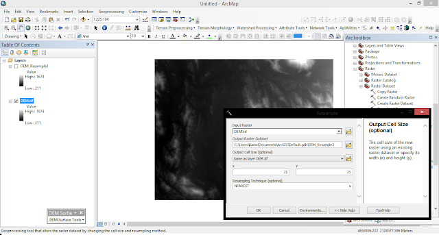
3. Open ArcToolBox >> Data
Management Tools toolbox / Raster Processing toolset >>Resample.
 |
| DEM Resample |
We now try to resample the 30
meter DEM to finer resolutions.
First we need to convert the DEM grid into elevation
points.
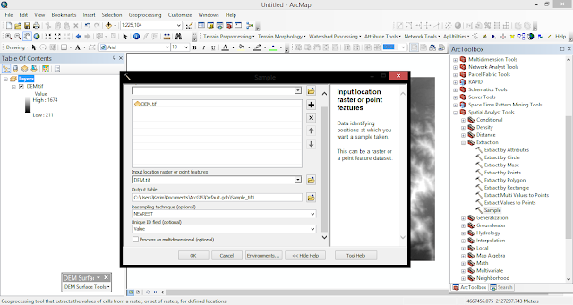
1. Spatial Analyst Tools toolbox /
Extraction toolset >> Sample.
 |
| DEM Sampling |
2. Specify dem 30m as the input raster and as the
input location raster, pnt30m_table.dbf as the output, and NEAREST
as the resample technique.
3. From the ArcMap Layer Panel, right-click on
pnt30_table.dbf and select Display XY Data.... Make sure x is in the X field,
y in the Y field, and dem30 in the Z field.
 |
| DEM Display points |
4. Export the point event data to a shapefile to make
them permanent. select Data / Export Data, and save the output as
pnt30.shp.
5. Use the spatial interpolation techniques to generate
DEMs from the point data set we just created. The first method we use is Inverse Distance Weighted (IDW).
ArcToolbox/Spatial
Analyst Tools/Interpolation.
 |
| DEM Interpolation |
6. The DEM automatically added to ArcMap uses a
symbology that is difficult to show the subtle variations in the DEM. Change
the symbology of the DEM layer from "classified" to
"stretched". With this display option, the DEM is displayed as a
grayscale map that shows the detail of the terrain.
Converting & Displaying DEM into DTM (Digital
Terrain Model)>>


This comment has been removed by the author.
ReplyDelete