Showing posts with label GIS and Remote Sensing. Show all posts

Wednesday, December 21, 2016

Landsat 8 Oli Processing

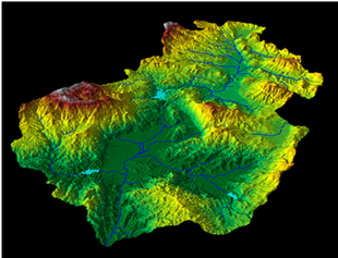
Subset of your image that only includes the areas our are interested in. This saves disk space and processing time. Some software packages refer to this process as subsetting while others use the term clipping. Most raster data can be subset using XY coordinates, vector files or user created Regions of Interest (ROI). This process always creates a new dataset that only contains your data subset.
Image Subset
Minimum noise fraction (MNF) transformation is used to show the variation between bands in an image. This is a statistical method which works out differences in an image based on pixel DNs in various bands. MNF determines the inherent dimensionality of image data, to segregate noise in the data, and to reduce the computational requirements for subsequent processing. This step is often completed as a precursor to other types of analysis. Basically it is a way of simplifying the data. The MNF transform is essentially two principal component transformations. The first transformation, based on an estimated noise covariance matrix, decorrelates and rescales the noise in the data. [2]
This first step results in transformed data in which the noise has unit variance and no band-to-band correlations. The second step is a standard principal components transformation which creates several new bands containing the majority of the information. By using only the coherent portions, the noise is separated from the data, thus improving spectral processing results. Once applying MNF technique, on the 7 bands images TM (After being calibrated in reflectance mode), we will have like result 7 new bands images MNF. The image pixels are presented by eigenvalues. In examining the eigenvalues it can be seen that the first MNF bands ( 1 and 2) have the highest values while the remaining bands have consistent low values. It is the first two bands with the large values that contain most of the information and it is these bands that correspond to MNF images. The remaining low value bands (3 and under for example) are seen as noise. The images show the information compressed into only a few bands. The redundancy of the data is eliminated and noise is also removed. The result are more interpretable images. You could say that the data has been simplified or the dimensionality has been reduced. 
Eigenvalues Images
Optimum Index Factor (OIF) is a statistic value that can be used to select the optimum combination of three bands in a satellite image with which you want to create a color composite. The optimum combination of bands out of all possible 3-band combinations is the one with the highest amount of 'information' (= highest sum of standard deviations), with the least amount of duplication (lowest correlation among band pairs). The limitation of the OIF calculation is that, the best combination for conveying the overall information in a large scene may not be the best combination for conveying the specific information desired by the image analysis. This from experience in most cases is reasonable and that also depends on the type of study. The aim of this study is to use OIF technique to rank all the possible three-band combinations with the best favorable for geological mapping of El-Beda Prospect. [3] Based on the results obtained from OIF, the combination 7, 2 and 1 shows the highest value of OIF with the first rank. This band combination has the most information with the least amount of duplication so that the boundaries between rock units and other geological features are very clear.
Optimum Index Factor (OIF)
[2] J.W. , Boardman & F.A. , Kruse ; Thematic Coference on Geologic Remote Sensing, Environmetal Research Institute of Michigan, Ann Arbor, MI, I: 407-418; (1994); "Automated spectral analysis: A geologic example using AVIRIS data, noth Grapevine Mountais, Nevada".
[3] Ali M. Qaid and H.T. Basavarajappa ; American-Eurasian Journal of Scientific Research 3 (1): 84-91, 2008 ISSN 1818-6785"Application of Optimum Index Factor Technique to Landsat-7 Data for Geological Mapping of North East of Hajjah, Yemen".
Share:

Tuesday, December 20, 2016

Landsat 8 Preprocessing

Landsat 8 Preprocessing

Pre-processing of Landsat-8 OLI/TIRS data stage consists of those operations that prepare data for subsequent analysis that attempts to correct or compensate for systematic errors. The digital images are subjected to several corrections such as radiometric and atmospheric. Landsat-8 data were converted to surface reflectance by top-of-atmosphere (TOA) method Using Envi, which is recommended for calibration in mineralogical mapping, as it does not require prior Knowledge of samples collected in the field. Thermal atmospheric correction was performed on TIR bands with a normalized pixel regression method [1]. The 90-m resolution TIR bands were re-sampled to correspond to 30-m spatial dimensions for some image processing applications. Nearest neighbor re-sampling Was used to preserve the original pixel values in the re-sampled images.
Radiometric correction is done to reduce or correct errors in the digital numbers of images. The process improves the interpretability and quality of remote sensed data. Radiometric calibration and correction are particularly important when comparing data sets over a multiple time periods. The energy that sensors onboard aircrafts or satellites record can differ from the actual energy emitted or reflected from a surface on the ground. This is due to the sun's azimuth and elevation and atmospheric conditions that can influence the observed energy. Therefore, in order to obtain the real ground irradiance or reflectance, radiometric errors must be corrected for. The value recorded for a given pixel includes not only the reflected or emitted radiation from the surface, but also the radiation scattered and emitted by the atmosphere. In most cases were are interested in the actual surface values. To achieve these values radiometric calibration and correction must be applied.
Calibrated A sensor records the intensity of the electromagnetic radiation for each pixel as a digital number (DN). These digital numbers can be converted to more meaningful real world units like radiance, reflectance or brightness temperature. Sensor specific information is needed to carry out this calibration. In the case of Landsat data, the metadata file contains this information. Most image processing software packages have radiometric calibration tools. In ENVI some Landsat data can be converted directly to reflectance, with out needing to first calculate radiance. The Radiometric calibration has been done by Envi.
Atmospheric correction is the process of removing the effects of the atmosphere to produce surface reflectance values. Atmospheric correction can significantly improve the interpretability and use of an image. Ideally this process requires knowledge of the atmospheric conditions and aerosol properties at the time the image was acquired. The data had been corrected by FLAASH Module in ENVI.
Radiometric calibration

Share:

Sunday, December 18, 2016

Sunday, November 22, 2015

Digital Elevation Model (DEM) Resolution Enhancement


03Surface Interpolation


This exercise will guide you through a Method to generate a New finer resolution of a DEM

1. Add the dem grid to ArcMap. Check if the grid has a 30 meter cell size and a UTM projection.

2. Enable Spatial Analyst extension From Customize > Extension.


3. Open ArcToolBox >>  Data Management Tools toolbox / Raster Processing toolset >>Resample.

DEM Resample
DEM  Resample

We now try to resample the 30 meter DEM to finer resolutions. 
First we need to convert the DEM grid into elevation points. 

1. Spatial Analyst Tools toolbox / Extraction toolset >> Sample.

DEM Sampling
DEM Sampling

2. Specify dem 30m as the input raster and as the input location raster, pnt30m_table.dbf as the output, and NEAREST as the resample technique

3. From the ArcMap Layer Panel, right-click on pnt30_table.dbf and select Display XY Data.... Make sure x is in the X field, y in the Y field, and dem30 in the Z field. 


DEM Display
DEM Display points

4. Export the point event data to a shapefile to make them permanent. select Data / Export Data, and save the output as pnt30.shp.

5. Use the spatial interpolation techniques to generate DEMs from the point data set we just created. The first method we use is Inverse Distance Weighted (IDW). 

ArcToolbox/Spatial Analyst Tools/Interpolation.

DEM Interpolation
DEM Interpolation 

6. The DEM automatically added to ArcMap uses a symbology that is difficult to show the subtle variations in the DEM. Change the symbology of the DEM layer from "classified" to "stretched". With this display option, the DEM is displayed as a grayscale map that shows the detail of the terrain.

Converting & Displaying DEM into DTM (Digital Terrain Model)>>
Share:

Friday, July 10, 2015

Digital Elevation Models (DEM)

01 Digital Elevation Models (DEM)
Digital Elevation Models (DEM)


INTRODUCTION
A DEM is a raster representation of the Altitude provide basic, quantitative information about the Earth’s surface. The accuracy of this data is determined primarily by the resolution (the distance between sample points). Other factors affecting accuracy are data type (integer or floating point) and the actual sampling of the surface when creating the original DEM.

Most data providers and professional users use the term DEM for both the digital terrain model (DTM) and digital surface model (DSM). A DTM usually refers to the physical surface of the Earth (elevations of the bare ground surface) without objects such as vegetation or buildings, while a DSM describes the upper surface of the landscape, includes the height of vegetation, man-made structures and other surface features, and only gives elevations of the terrain in areas where there is little or no ground cover (Maune, 2007). 

Elevation data sets, from which DEMs are generated, are obtained by a broad range of measurement techniques, such as ground survey (GPS, total station, terrestrial, and laser scanner), airborne photogrammetric imagery, airborne laser scanning (LiDAR), radar altimetry and interferometric synthetic aperture radar (InSAR).

TERMINOLOGY
Digital Elevation Model (DEM): generic term for altitude grid.
Digital Terrain Model (DTM): ground elevation model.
Digital Surface Model (DSM): ground + cover elevation model.
Digital Height Model (DHM): cover elevation model.
DEM Types

The digital elevation model corresponds to a regular grid of elevation. Each node of the grid shows an altitude value.
The resolution of the grid corresponds to the distance between to neighbor nodes.

DEM Scales Vs Sources


Global Scale
The GTOPO30 DEM was created based on heterogeneous topographical maps. The quality of the elevation data varies consequently over space.
The SRTM30 DEM was acquired through space shuttle radar interferometry. This new source of elevation data overcome the major quality problems of the GTOPO30.
They both present a resolution of 30 arc seconds (~900 m) and are freely available for the Earth surface.

Regional Scale
SRTM 90 Vs 30 DEM.The SRTM 90 & 30 m DEM were acquired through space shuttle radar interferometry.
They present a resolution of 3 arc seconds (~90 m) respectively 1 arc seconds (~30 m) and are available for the Earth surface.
The SRTM 90 m is freely available. The SRTM 30 m costs being of 0.5 $ per square kilometer. 

Local Scale (LASER DEM)
LASER DEMThis new acquisition technology allows the capture of very high resolution DEM (~1 m). Both terrain (ground) and surface (objects) are captured in the same time. Such detailed digital elevation model offers good potential for local relief analysis in applications such as hydrology, hazard mapping. The cost of acquisition are relatively high (150-300$ per square kilometer).

(LASER DEM)

The ASTER GDEM is provided at a one arc-second resolution (approximately 30m). The absolute vertical accuracy of ASTER GDEM is 20 m at 95% confidence level.
(ASTER GDEM2) was introduced to improve the spatial resolution, and increase the accuracy of water body coverage.
The Global Multi-resolution Terrain Elevation Data 2010 (GMTED2010) was generated at three separate resolutions of 30 arc-seconds, 15 arc-seconds, and 7.5 arc-seconds (approximately 1 km, 500 m and 250 m, respectively).

Examples of the topography detail displayed by the selected digital elevation models.

Usage of DEM
(1) Hydrological modelling including flood simulation, delineation and analysis of watersheds and drainage networks,
(2) Soil erosion and sediment transport modelling,
(3) Delineation and study of physiographic units,
(4) Soil and ecological studies,
(5) Geomorphological evaluation of landforms,
(6) Civil engineering and military applications such as site and route selection, landslide hazard assessment, visibility analysis (viewshed analysis), and
(7) Remotely sensed image enhancement for 3D analysis. Groundwater and climatic models also use digital topographic data as essential components. Digital elevation models provide an opportunity to characterize quantitatively land surface in terms of slope gradient and curvature and yield digital terrain information not blurred by land cover features which is often a problem in stereo-aerial photograph interpretation and remotely sensed image analysis.


Displaying Digital Elevation Model (DEM)/ (DTM)

Displaying Digital Elevation Model (DEM)-(DTM).

Analyzing Surfaces Terrain / DEM analysis tools
Some of these tools are primarily designed for the analysis of raster terrain surfaces. These include Slope, Aspect, Hillshade, and Curvature tools.

1.      Calculating Slope
It affects where structures or trails can be built, crops can be planted or harvested, the speed of flowing water and consequent erosion, landslide potential, and the list just goes on and on.
The Slope tool calculates the maximum rate of change from a cell to its neighbors, which is typically used to indicate the steepness of terrain. (0-90) degree.

Slope Calculation

  2.  Calculating Aspect
Aspect identifies the slope direction in compass degrees from 0 (due north) to 360.
The aspect of a surface typically affects the amount of sunlight it receives (as does the slope); in northern latitudes places with a southerly aspect tends to be warmer and drier than places that have a northerly aspect. Aspect is an important contributor to vegetation and habitat type, as north-facing slopes often have very different conditions and temperatures than south-facing slopes.

Aspect Calculation

     3.  Hillshade
Hillshade allows us to determine the illumination of a surface (the DEM in the case) given a direction and angle of a light source (i.e. the sun). The resultant grid contains values ranging from 0-255 with 0 representing complete darkness.
Hillshading is an extremely useful way to depict the topographic relief of a landscape. Few methods are as intuitive and easy to understand as a hillshade. A good hillshade lets you understand immediately what areas are ravines, ridges, peaks or valleys.

Hillshade Calculation.

     4.  Curvature
Calculates the slope of the slope (the second derivative of the surface), that is, whether a given part of a surface is convex or concave. Convex parts of surfaces, like ridges, are generally exposed and drain to other areas. Concave parts of surfaces, like channels, are generally more sheltered and accept drainage from other areas. The Curvature tool has a couple of optional variants, Plan and Profile Curvature. These are used primarily to interpret the effect of terrain on water flow and erosion. The profile curvature affects the acceleration and deceleration of flow, which influence erosion and deposition. The planiform curvature influences convergence and divergence of flow.

Curvature Calculation.

Note
From an applied viewpoint, the output of the Curvature tool can be used to describe the physical characteristics of a drainage basin in an effort to understand erosion and runoff processes. The slope affects the overall rate of movement down-slope. Aspect defines the direction of flow. The profile curvature affects the acceleration and deceleration of flow and, therefore, influences erosion and deposition. The plan form curvature influences convergence and divergence of flow.
Displaying contours over a raster may help with understanding and interpreting the data resulting from the execution of the Curvature tool. An example of the process follows >>
1.       Use Contour to create contours of the raster.
2.      Create a slope raster.
3.      Contours of the slope.
4.      Add the curvature raster as a layer in ArcMap. Overlay the two contour coverage just created, and apply different color symbology for each.

Sources 
A book of "DTM Principles and Methodology"
Arc GIS online Courses 
Share:
Blog Directory & Business Pages - OnToplist.com
K.Amen. Powered by Blogger.
Subscribe Via Email

Sign up for our newsletter, and well send you news and tutorials on web design, coding, business, and more! You'll also receive these great gifts:

Science Blog Directory