Sunday, December 18, 2016
Wednesday, December 9, 2015
Pearls
Pearls are the most valuable of all organic gemstones, and have been prized for 6000 years. Pearls chemical makeup varies by region and environmental factors, but the basic formula is CaCO3. Pearls form through irritants entering specific species of mollusks (oysters, clams, muscles, etc), while the irritant can be a grain of sand or a parasite, the process is the same for pearls. The irritant is coated in CaCO3(mother of pearl) to make it less irritating to the mollusk.
Saturday, December 5, 2015
3D Map Generator – GEO
Available for PC and MAC as Plugin for
Photoshop CC (from v 14.2)
The 3D Map Generator – GEO“ is especially created for illustrating complex geographical 3D maps. In opposite to the current „3D Map Generator 2“ the new „3D Map Generator – GEO“ can be used to create big 3D maps in smaller map scales. With a few clicks it is possible to generate isometric 3D maps in 3 different orientations with heights and depths in the terrain. As basic shapes there can be used text layers, vector shapes, Smart Objects or one of 52 vector country shapes. For designing the map there are different new tools, textures, effects, brushes and 37 icons and elements available. The generated 3D maps can be edited and redesigned for unlimited times. No layers will be flattened. Of course it is also possible to put own textures onto the surface and to use own brushes, effects, icons or other elements.
Wednesday, December 2, 2015
Tuesday, December 1, 2015
Monday, November 23, 2015
Aurichalcite with Calcite E Vs Blue Opal
Sunday, November 22, 2015
Digital Elevation Model (DEM) Resolution Enhancement
This exercise will guide you through a Method to
generate a New finer resolution of a DEM.
1. Add the dem grid to ArcMap. Check if the grid
has a 30 meter cell size and a UTM projection.
2. Enable Spatial Analyst extension From Customize
> Extension.
3. Open ArcToolBox >> Data
Management Tools toolbox / Raster Processing toolset >>Resample.
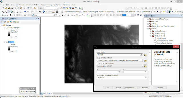
![]() |
| DEM Resample |
We now try to resample the 30
meter DEM to finer resolutions.
First we need to convert the DEM grid into elevation
points.
1. Spatial Analyst Tools toolbox /
Extraction toolset >> Sample.
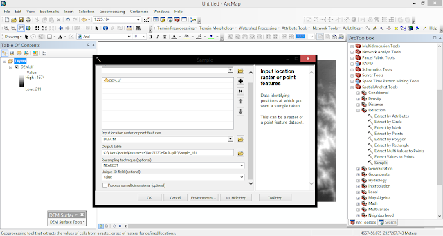
![]() |
| DEM Sampling |
2. Specify dem 30m as the input raster and as the
input location raster, pnt30m_table.dbf as the output, and NEAREST
as the resample technique.
3. From the ArcMap Layer Panel, right-click on
pnt30_table.dbf and select Display XY Data.... Make sure x is in the X field,
y in the Y field, and dem30 in the Z field.
![]() |
| DEM Display points |
4. Export the point event data to a shapefile to make
them permanent. select Data / Export Data, and save the output as
pnt30.shp.
5. Use the spatial interpolation techniques to generate
DEMs from the point data set we just created. The first method we use is Inverse Distance Weighted (IDW).
ArcToolbox/Spatial
Analyst Tools/Interpolation.
![]() |
| DEM Interpolation |
6. The DEM automatically added to ArcMap uses a
symbology that is difficult to show the subtle variations in the DEM. Change
the symbology of the DEM layer from "classified" to
"stretched". With this display option, the DEM is displayed as a
grayscale map that shows the detail of the terrain.
Converting & Displaying DEM into DTM (Digital
Terrain Model)>>